Hydrographic and Pipeline Surveys: From Near-Shore to Offshore
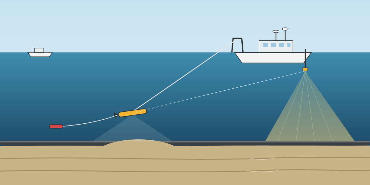
A pipeline survey in three metres of water and a pipeline survey in sixty metres of water have the same name on a scope of work. In the field they are different jobs. The boat, the sensors, the crew and the way the data is checked all change as the water gets deeper and the shore gets further away.
This is the third article in a series based on a project execution plan I prepared for a topography and positioning services package. The first article covered the plan as a whole, and the second covered geodetic control. This one looks at the largest family in the plan: hydrographic and pipeline surveys. Client, project, field and location details are left out.
Ten service lines, five pairs
The plan listed ten hydrographic and pipeline services. They are really five survey types, each in a near-shore version and an offshore version:
- General bathymetry (with object marking near-shore).
- Multibeam bathymetry.
- Pipeline inspection near-shore, and pipeline identification offshore.
- Pipeline route survey.
- Seabed clearance survey.
Near-shore meant from the shoreline out to roughly 4 nautical miles. Offshore meant anything further out. Writing the equipment and crew tables for each pair side by side was the clearest way to see what actually changes between the two.
A note on "analogue"
Several service lines in the scope were called "analogue" surveys: analogue pipeline inspection, analogue pipeline route survey, analogue seabed clearance. In this context the word is used for the geophysical sensors, such as side scan sonar, magnetometer and sub-bottom profiler, as opposed to the bathymetric sensors that measure depth. The analogue sensors answer a different question. Bathymetry tells you how deep the seabed is. Analogue data tells you what is on it and under it: pipelines, debris, anchor scars, boulders, buried objects and shallow geology.
Bathymetry: start simple
The simplest service is near-shore general bathymetry with object marking. The spread in the plan was:
- A single WADGNSS positioning system.
- A magnetic fluxgate compass for heading.
- A singlebeam echo sounder.
- An automatic shore tide gauge.
- Temporary marker buoys and node sticks for marking objects.
The crew was one surveyor, one positioning engineer and two helpers. That is enough to run lines from a small boat, reduce depths to datum using the tide gauge, and mark obstructions so that other vessels can see them.
Adding multibeam changes more than the sonar. A multibeam echo sounder measures a wide swath to each side of the boat, so the outer beams are sensitive to heading and to sound velocity. The plan therefore replaced the fluxgate with a gyrocompass, added a CTD profiler for sound velocity, and added a multibeam engineer to the crew. The singlebeam stays on board as a check against the multibeam nadir depths.
Offshore, general bathymetry and multibeam bathymetry use the same sensors as near-shore, with two changes: a dual positioning system instead of a single one, and a crew doubled for 24-hour working, with two surveyors, two positioning engineers and two helpers.
Pipeline work near-shore
Near-shore pipeline inspection is where the geophysical sensors come in. The spread was WADGNSS, a fluxgate, singlebeam, side scan sonar, a magnetometer and the shore tide gauge. The crew added a geophysicist.
Each sensor does a different job:
- Side scan sonar shows the pipeline as a line on the seabed image, with its shadow showing whether it is exposed or free-spanning.
- The magnetometer detects the steel pipe even where it is buried and invisible to sonar.
- The singlebeam gives the depth along the line, and with the tide gauge, the seabed level over the pipe.
A pipeline that the side scan cannot see but the magnetometer still detects is buried. A pipeline that the side scan sees with a clear shadow underneath may be spanning. Those two sensors together are what make an inspection survey more than a depth survey.
The near-shore route survey adds a gyro, multibeam and a CTD to the inspection spread, with a multibeam engineer in the crew. A route survey has to describe the whole corridor for a new pipeline, not just a line on the seabed, so full multibeam coverage matters. Seabed clearance near-shore uses the inspection spread without the magnetometer, aimed at finding debris and obstructions before work starts.
Pipeline work offshore
Offshore, the pipeline services become full geophysical surveys. The offshore route survey spread in the plan was:
- Dual WADGNSS positioning.
- Gyrocompass.
- Singlebeam and multibeam echo sounders.
- Side scan sonar.
- Sub-bottom profiler.
- Magnetometer.
- USBL system with a transponder.
- CTD profiler.
- A transducer pole.
- A three-phase generator to power the spread.
Pipeline identification and seabed clearance offshore use a similar spread. Three items stand out as new.
The sub-bottom profiler looks into the top layers of the seabed. On a route survey this shows soft sediment, buried channels and anything that could affect how a pipeline is laid or trenched.
The USBL positions towed or deployed sensors. In shallow water, a short layback calculation from the boat may be good enough for a towed sensor. In deeper water the sensor is a long way behind the boat, and only acoustic positioning tells you where it really is.
The generator and the transducer pole are a reminder that this spread is often installed on a vessel of opportunity, not a dedicated survey ship. Power and a rigid mount for the transducers have to be brought along.
The crew grows to match. The offshore route survey team in the plan was a senior surveyor and a surveyor, a senior geophysicist and a geophysicist, a multibeam engineer, a senior and a junior positioning engineer, two helpers and a data processor. That is ten people for one survey, and it reflects the amount of data coming off the boat each hour.
Calibrations that matter here
Most of the calibrations listed in the plan exist because of this family of surveys:
- Gyro calibration and offset measurement, because multibeam outer beams and towed sensor positions both depend on heading and offsets.
- Sound velocity, with a wet test of the sensor before mobilisation and profiles during the survey, because the multibeam needs the correct sound velocity both at the transducer and through the water column.
- USBL calibration, with a seabed transponder in more than 50 metres of water, six lines around it and a final check from four corners, because every offshore geophysical sensor position depends on it.
- DGNSS verification against known points on the wharf, because everything starts from the vessel position.
The plan's online navigation requirements apply here too: time-tagging from the GNSS pulse-per-second signal, a two-second update cycle at most, and logging of all raw sensor data.
Tides and datum
Every depth in this family has to be reduced to a datum, and near-shore that means a shore tide gauge, which appears in the equipment list for every near-shore service. The plan also stated that tidal corrections would use predicted tide data supplied by the client. A sensible survey compares predictions with the observed gauge readings. Where they disagree, for example during strong wind or high river flow in a delta, observed tides give the better result.
This is also where the geodetic control from the second article pays off. The tide gauge is only useful if its zero is tied by levelling to the same vertical datum as the land survey. Otherwise the bathymetry and topography will not meet at the shoreline.
Processing on board
The plan called for one data processor per shift, processing on board, using the client's file naming convention. Raw and processed data are both kept, processing steps are recorded, and the data can be reprocessed if needed. For geophysical surveys this matters a lot. The interpretation of a side scan contact or a magnetic anomaly is a judgement, and the client may want to look again at the raw records later.
What I took from it
- Same name, different survey. A near-shore and an offshore pipeline survey share a title, not a spread.
- Pair the services when planning. Writing each near-shore and offshore version side by side shows exactly what is added and why.
- Bathymetry answers depth. Analogue sensors answer what is there. Most pipeline questions need both.
- Heading and sound velocity become critical as soon as multibeam is used. The calibrations are not optional extras.
- Positioning the sensor is not the same as positioning the boat. Offshore, USBL is what connects the two.
- The tide gauge must be tied to the land datum, or the survey will not join up at the coast.