Positioning Support for Subsea Cable Lay: Barge, Anchors and Touchdown
Before this phase, we had surveyed the seabed for a new 15 kV subsea power cable between Pabelokan Island and the NORA-A platform in the Offshore South East Sumatra (OSES) block. That survey told the project what was on the seabed. The next question was how to put a cable and a set of anchors on that seabed without hitting anything already there.
I prepared the Survey Positioning Procedure for the cable lay phase, for PT Explora Prima as the positioning contractor. This article walks through how that procedure was put together and why each part is there. It is a plan, not a lay report, but most of the thinking applies to any barge-based cable or pipe lay in a crowded field.
The operation
The cable was about 9.75 km long, laid from Pabelokan Island to NORA-A. The spread was:
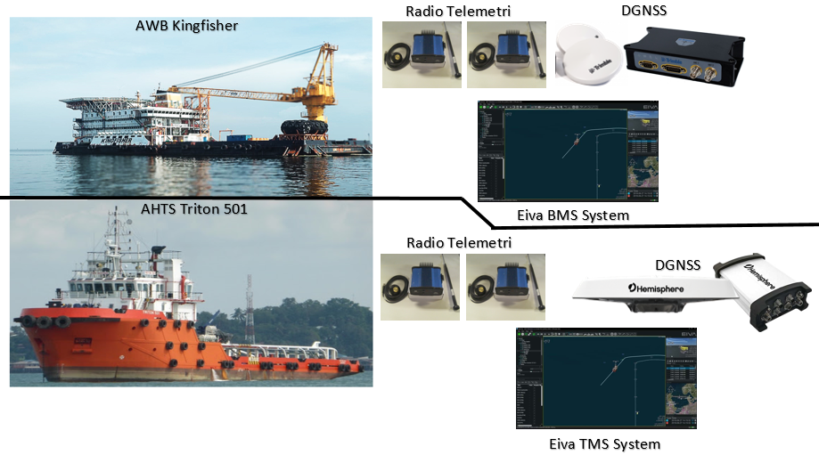
- AWB Kingfisher, an accommodation work barge with a swan tower to lay the cable.
- AHTS Triton 501, an anchor handling tug to run and recover the barge anchors.
A moored barge moves by pulling itself along on its anchor wires. Every few hundred metres, the tug has to pick up an anchor and drop it again further along the route. Each anchor drop and each wire is a risk to the pipelines and cables already on the seabed. On this route, the seabed survey had found eight pipelines and seventeen cables in the corridor, plus a shallow, coral-covered shore approach on the Pabelokan side and busy marine traffic around NORA-A.
So the positioning job was not only "where is the barge". It was "where is every anchor, every wire and the cable touchdown, relative to everything we must not touch".
Two survey systems, one picture
The procedure set up two linked systems:
- Main unit on the barge: EIVA NaviPac in Barge Management System (BMS) mode, with Trimble DGNSS on MarineStar correction for position and heading.
- Auxiliary unit on the tug: EIVA NaviPac in Tug Management System (TMS) mode, with its own Hemisphere DGNSS.
The two were connected by radio telemetry, so the barge could see the tug and the tug could see the barge, the anchor pattern and the target drop points in real time, with updates every second.
A remote helmsman display went to the winch operator and the tug bridge. This matters more than it sounds. The survey desk can have perfect data, but anchors are dropped by the tug master and wires are hauled by the winch operator. If they cannot read the display, the positioning is useless.
Standards and references
The procedure followed the IMCA survey guidelines that are standard for this type of work, including:
- IMCA S 012 on installing and maintaining DGNSS positioning systems.
- IMCA S 015 on GNSS positioning in oil and gas (joint with IOGP).
- IMCA S 016, the mobilisation checklist for offshore survey.
Using recognised guidelines makes the procedure easier to approve and gives the offshore team a common reference when there is a disagreement.
Mobilisation: set up once, check twice
Most positioning errors are made in port, not offshore. The procedure put a lot of weight on mobilisation:
- A survey pack prepared before leaving the office: scope, procedures, manuals, software, the field database and personnel documents.
- A dry test and mock-up of the full system in the workshop.
- On board: install the sensors and displays, then measure and verify everything.
Offsets. All offsets are measured from one Common Reference Point at the stern centre of the barge, using land survey methods (total station), and then checked independently with tapes. The DGNSS antennas, the swan tower, the fairleads and any other point of interest are all tied to that reference.
DGNSS and heading verification. With the barge tied up and stable, a total station on the quay observes prisms set under the GNSS antennas, with at least 15 readings. The observed positions are compared with the positions logged in NaviPac at the same time. For heading, targets on the bow and stern, placed parallel to the barge centre line, are observed in sequence and compared with the logged heading. The rule is simple: the vessel does not leave the jetty until this is done and signed off.
Geodesy. The client grid is Batavia (Bessel 1841) on a Transverse Mercator projection with the central meridian at 108° E. As on the seabed survey, the transformation from WGS84 is tested in the software against a known test point before any operations. The procedure also stated LAT as the vertical datum for offshore elevations and depths.
The field database
The procedure required the latest field database on screen at all times, as background for the barge and tug. At a minimum it had to include:
- Geodetic parameters, survey date and equipment.
- Bathymetry and the debris list from the seabed survey.
- All seabed assets: pipelines, cables and other man-made objects.
- Coastline and platforms.
This is where the seabed survey pays off. The pipeline crossings, the debris contacts and the coral area near the island become lines and polygons on the barge display, with buffer zones around them.
Anchor handling
Before each move, the mooring master provides the planned transit route, holding position, mooring approach, beach pull location and anchor pattern. The surveyor checks these against the field database before anything happens on deck. If an anchor is planned inside an asset buffer, or a wire will cross a pipeline or cable, the surveyor raises it early enough for the plan to change.
The pre-mooring checks were:
- The anchor pattern is loaded on the navigation screen.
- Every planned anchor position is in a safe zone outside the asset buffer.
- Where an anchor wire crosses a pipeline or cable, a mid-line buoy is planned to lift the wire clear.
- Distance and bearing to each anchor are confirmed.
During the move, the survey team gives the tug its targets and waypoints for pick-up and drop, marks the actual drop positions, watches for anchor drag, and records everything. The tug master follows the TMS display. The barge sees where each anchor really went, not where it was supposed to go.
Cable lay
During lay, the surveyor's job is to keep the touchdown point on the planned route. The barge position and heading are monitored continuously, fixes are logged with numbering that matches the lay crew's numbering, and the layback reported by the field engineer is recorded so the as-laid position can be calculated. Every event goes into a structured log: start and end of line, fix numbers, positions, offsets, setting changes and heading.
Station keeping at the platform
The most sensitive moment is when the barge works close to NORA-A. Weather or a winch problem can move a barge a few metres in a short time, and a few metres is enough to hit a jacket. The procedure required:
- A ghost barge on the display showing the target position.
- A track trail so any drift is visible at a glance.
- A geofence in NaviPac that sounds an alarm if the barge moves outside the allowed box.
- Continuous monitoring of positioning reliability by the online surveyor.
Real-time QC
Positioning that cannot be trusted is worse than no positioning, because people act on it. The online surveyor monitors, on time series plots:
- GNSS correction status and position quality.
- Heading from the receiver.
- Update rates of all sensors, with a navigation cycle time no longer than 2 seconds.
- The difference between the primary and secondary positioning systems.
If primary and secondary start to disagree, that is the first sign of a problem, long before anyone on deck can see it.
Reporting
The procedure kept reporting simple and regular:
- A daily survey log of equipment, software, geodetic changes, failures and weather.
- A daily progress report covering the last 24 hours, the plan for the next 24 hours, downtime and HSE.
- Field reports for specific events, such as an on-site calibration.
- A final report with methods, calibrations, offsets, geodesy and the record of operations.
Project data was backed up every day.
Safety
Survey people on a lay barge work on deck, near open edges and under moving wires. The procedure set out the PPE requirements, life jackets near the vessel side, harnesses above 2 m, and a stop work policy that gives anyone the authority to stop a job they believe is unsafe. A positioning team that sees a problem on the screen must also feel free to stop the operation.
What I took from writing it
- A positioning procedure is really a communication plan. The data has to reach the tug master and the winch operator in a form they can use quickly.
- The seabed survey and the lay procedure are one piece of work. Every hazard found in the survey should appear as something on the barge display.
- Verification in port is the cheapest insurance in the project. Offsets, DGNSS and heading checked against a total station take a few hours. A wrong offset found during lay costs days.
- Plan for the platform approach first. It is the shortest part of the job and the one with the least room for error.