Survey Support for Diving and ROV Work at Offshore Platforms
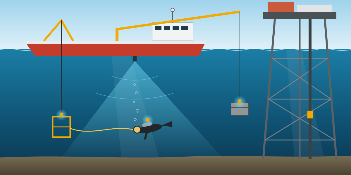
Most offshore survey articles are about pipelines and seabed mapping. A lot of real survey work is quieter than that: keeping track of a dive support vessel next to a platform, and of the divers and ROV working under it. When an inspection, repair and maintenance (IMR) campaign installs clamps on risers or lays a short cable between platforms, survey is what tells everyone where the vessel, the diver and the load actually are.
This article is based on survey procedure for diving and ROV positioning, written for an IMR campaign on ageing shallow-water platforms. I was involved as project surveyor and surveyor. It covers what such a procedure has to include and why. Client and field details are left out.
Two layers of positioning
Survey support for diving and ROV work has two parts:
- Surface positioning: the vessel or barge, its heading, and the offsets to every point that matters, such as the dive bell or cage launch point, the ROV launch point and the crane.
- Underwater positioning: acoustic positioning, usually USBL, sometimes LBL, to track divers, the bell or cage, the ROV and anything being lowered.
The underwater system hangs off the surface system. A USBL position is only as good as the vessel position, heading and transducer offsets behind it. That is why most of the procedure is about getting the surface layer right.
The spread
A typical spread for this kind of work, and the one in this procedure, was:
- EIVA NaviPac as the online navigation software.
- Dual-frequency DGNSS with a high-accuracy correction service (around 8 cm), with the primary antenna as the common reference point.
- A survey-grade gyrocompass.
- USBL, either a HiPAP system already fitted on the DP vessel or a portable Sonardyne Scout.
- At least six subsea beacons, including spares.
- Remote navigation displays in the dive control shack, the ROV control room and on the bridge.
The minimum offshore crew was a party chief, a senior surveyor and a senior engineer, so that positioning was covered 24 hours a day.
What the client has to supply
The procedure was clear about what survey needs before mobilisation:
- Vessel details and drawings.
- The site layout in CAD, in the correct coordinate system.
- The project procedures and schedule.
- Geodetic parameters and a control point for checking GNSS and gyro alongside.
If there is no control point in port, the survey team sets a temporary benchmark and observes it with static GNSS. Without known control, there is nothing to verify the vessel against.
Mobilisation and checks in port
Like most survey procedures, this one put the weight on mobilisation. The vessel should not leave the jetty until every system is installed, tested and verified.
Offsets. All sensor offsets are measured to the primary GNSS antenna using a total station, then checked with tapes. The vertical reference is the main deck, and the height of the deck above the water is measured before sailing, whenever the vessel is alongside, and whenever it takes on fuel or water. A vessel that takes on a few hundred tonnes of fuel sits lower, and that changes every depth that depends on the transducer.
GNSS and gyro. With the vessel tied up and stable, prisms under each antenna are observed from a total station on the quay, at least 15 readings each, and compared with the positions logged in NaviPac. For heading, targets on the bow and stern, placed parallel to the centre line, are observed and the computed heading compared with the gyro. The checklist before starting is short and practical: receivers fully initialised and corrected, each one computing independently, more than five satellites, logging at one second, and the surveyor's watch synchronised to the logging clock.
Static USBL check. Two beacons are lowered at the bow and stern, on a line parallel to the vessel centre line, and logged for at least 15 minutes together with the gyro. The heading computed from the two beacon positions is compared with the gyro heading. It is a quick way to catch a transducer that has been installed with the wrong alignment. A full USBL calibration can follow in the field when time allows.
Geodesy. The procedure used WGS84 on UTM, with a test coordinate transformed in NaviPac at mobilisation and compared with known values. Bathymetry and elevations were referenced to LAT.
Approaching the platform
The first risk of the day is the approach. The bridge needs:
- The correct vessel outline with sensor and launch point offsets.
- Vessel movement shown graphically and numerically: track plot, coordinates, speed, heading and course made good.
- The field layout: platforms, pipelines, cables and any other vessels in the area.
Station keeping
Once on location, the vessel holds position close to the platform for hours with divers in the water. The procedure required:
- A ghost vessel showing the target position.
- A track trail so drift is visible.
- A geofence that sounds an alarm if the vessel moves outside an allowed box.
- Other DP reference systems, such as taut wire, laser or a seabed beacon, in addition to GNSS.
- The online surveyor watching GNSS quality continuously.
With divers deployed, a positioning problem is not just a delay. It is a safety problem.
Tracking the dive bell or cage
At least one beacon goes on the dive cage or bell. It shows the cage position and depth, and how far it has been pushed from the launch point by current. The interrogation rate is reduced in calm weather and increased in rough weather. The surveyor reports the cage depth during descent and ascent and at working depth, and warns the dive supervisor and the bridge about any obstruction near the deployment path.
Tracking the diver
The diver must be trackable at all times:
- Each diver is shown on the screen with a clear icon and name, so two divers are never confused.
- The dive shack has its own display showing the diver relative to the cage, the vessel and the platform.
- On request, the surveyor gives the diver a waypoint, range and bearing to the target.
- Fixes are taken on important features, such as pipelines, cables, conductors and work baskets, without cluttering the display.
Positioning the load
One small detail in the procedure is worth mentioning: a beacon on the crane sling that lowers the work basket or clamp. With it, the dive supervisor can see where the load is relative to the diver and talk to both the crane operator and the diver using the same picture. Moving heavy steel near a diver is the most dangerous part of the job, and a beacon on the load costs very little.
Records
Throughout the operation the surveyor records:
- All sensor positions at one-second intervals.
- Fixes on events, with depth, position, time and event code.
- Snapshots of the navigation screen and of the diver or ROV video.
- A structured event log.
For cable lay, each line is logged with start and end times, line and fix numbers, offsets, setting changes and vessel heading, and the laid track is fixed using layback or the diver or ROV beacon. When the installation is complete, a visual and as-built survey closes out the job.
NaviPac was set up to sample and compute all positioning data with a cycle time no longer than two seconds, display it in real time, flag non-conforming data, and log all raw data. Data was backed up every day.
Real-time QC
The online surveyor watches, on time series plots:
- GNSS correction status and position quality.
- Gyro heading.
- The secondary positioning system from the vessel.
- Update rates of every sensor.
- USBL positions.
- The difference between primary and secondary positioning.
A growing difference between primary and secondary is usually the first sign of trouble.
Reporting
Daily survey logs, a daily progress report covering the last 24 hours and the plan for the next 24, field memos for important events (such as a visual inspection, a debris fix, a laid cable or a clamp as-built), and a final report with calibrations, offsets, geodesy and operations.
What I took from it
- Divers change the priorities. In a pipeline survey, the main risk is bad data. In diving support, the main risk is people. Every display and alarm should be designed with that in mind.
- The dive shack needs its own screen. A dive supervisor should not have to ask the survey desk where their diver is.
- Track the load as well as the people. A beacon on the crane sling is one of the cheapest safety measures on the job.
- Re-measure the deck height when the vessel changes. Fuel, water and cargo all change the draft.
- A general procedure is a starting point. This one said so itself: once the detailed scope is known, the survey team writes a project-specific procedure based on it.